Status/News (Jan 2010): The DCR has put out to bid the construction of the $3,650,000 ARRA stimulus project to greatly improve the Alewife Brook paths from Alewife station to the Mystic Valley Parkway.
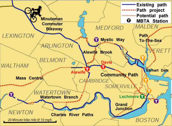
The reconstructed Alewife Brook multi-use paths (also called the Minuteman Connector) will wind along both sides of Alewife Brook throught the DCRs' Alewife Reservation. The Cambridge/Somerville side paths will be paved and the Arlington side will be stone dust. They'll connect Alewife station and the Minuteman Bikeway to Mystic Valley Parkway where they will join existing and future multi-use paths up and down the Mystic River (and hopefully to a new Green Line station on Route 16)
The Red (subway) Line's Alewife Station is a junction point (map) for five major existing & potential regional paths and a major transportation hub, which already sees significant walking & bicycle access, especially from the Minuteman Bikeway rail trail.
There are a number of groups supporting the reconstruction of these paths and improvments to Alewife Reservation to create a connected network of safe, accessible, and useful pedestrian & bicycle paths through our communities:
The Alewife Brook forms a boundary between Arlington, Cambridge and Somerville, in Massachusetts USA.
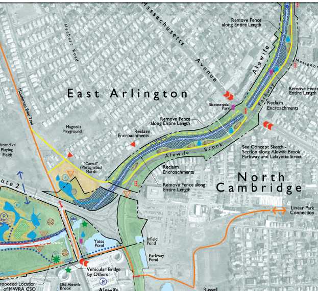
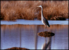
The area along the brook is state parkland managed by the Metropolitan District Commission (MDC) as the MDC Alewife Brook Reservation, and the Alewife Brook Parkway. The area has some incredible natural treasures, and some very serious problems. The park has not been high on the MDC's priority list, and has been largely ignored since the last major changes were completed in 1909. There have been benefits to this neglect -- the area is a haven for birds and other wildlife who have lived here undisturbed and largely unnoticed.
The firm bioengineering.com and the DCR has produced a new 'master plan' for the Alewife reservation. This master plan amounts to a series of maps & pictures showing what the area could be, should politicians decide to invest in restoration. The master plan articulates a vision of what is possible, though all details are subject to funding and future design review.
The plan, as presented, calls for public access, flooding mitigation, habitat restoration and protection, in balance. The regional path connections take center stage, as the thread that holds the rest of the plan together, and the reason people outside the immediate area will care about (and fund) the effort.
Please note: The MDC owns the river, but can't directly control what gets
put into it. Separate and intense debate continues over issues of upstream land
use, flooding and sewage. The MDC only owns the river, not the pipes that feed
into it. Please contact the MWRA (Massachusetts Water Resources Agency) and FEMA
(Federal Emergency Management Agency) for more information on the flooding
situation, as it affects homes built in the floodplain. 
New path connections are a core part of the 'master plan', and a core part of our goals as a path advocacy group. Paths serve both recreation and transportation needs, both for local residents and for visitors. These paths should offer great wildlife and natural habitat viewing, clear transportation benefits for local residents, and contribute to revitalizing the area.
Some of the proposed paths are paved, some unpaved. The unpaved paths will use a wheelchair compatible stone dust/soil binder formula that does not get muddy, even in heavy rain.
The Friends will work cooperatively with town, city & state agencies to ensure a community voice in the design process. The Friends will work to contact and involve all interested parties, and to make sure that solutions to concerns are given proper attention.
Paths have been a big boost to many communities: we will work for a good path here. A Federal government program exists to fund local path projects. Of all 50 states, Massachusetts makes the least use of this money, spending just 17% of the available funds. A solid path program can help us bring more money to the neighborhood! Paths will contribute, not take away, from solutions to other Alewife area problems.
All Alewife neighbors are invited to become involved, or simply to provide
input. If you object to the proposed improvements, that's OK also. All
voices are welcome. Perhaps we can work together to solve the issues
and build a better neighborhood for everyone.
Keeping a path safe requires some police efforts. Experience with other paths has shown that the nicer the path, the less problems there are. There have been plenty of poorly maintained areas that, once cleaned up, suddenly had less crime also.
Years ago there was a problem where local police did not have jurisdiction on MDC land. This loophole, which helped encourage crime on MDC land, has been closed:
"MGL 92/37 TITLE XIV. PUBLIC WAYS AND WORKS: A police officer employed by a city or town in whose boundaries, reservations or boulevards are located shall have all the same powers they have as a police officer of the city or town to enforce the laws of the commonwealth and the rules and regulations of the commission on any bikeway, pathway, park, reservation or other land under the care of the commission."
Website design by Obviously
Enterprises, updated January 2010 by Alan Moore.